
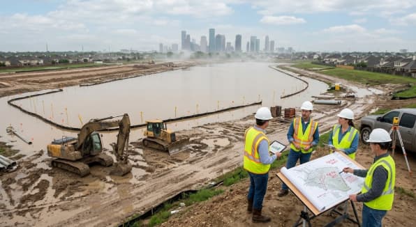
Houston sits on flat coastal clay, laced with bayous, and squarely in the path of Gulf moisture. That combination makes it one of the most flood-exposed metro areas in the country, and it also makes flood zone designation one of the biggest hidden variables in a construction estimate. A contractor who prices a site the same way in Zone X and Zone AE is going to be wrong on one of those bids, sometimes by a significant margin.
For estimators, understanding Houston’s flood zone map isn’t a nice-to-have. It shapes cut and fill volumes, drives detention pond sizing, adds line items for erosion control and dewatering, and can push a foundation design from a standard slab to an elevated system that costs tens of thousands more. This guide breaks down how Houston’s flood zones work, where they sit across the city, and exactly how they change an earthwork and civil estimate.
Why Flood Zones Matter More in Houston Than Almost Anywhere Else
Houston’s flood risk isn’t a coastal quirk. It’s structural. The region sits on heavy clay soil that doesn’t absorb water quickly, the terrain is nearly flat so runoff has nowhere to go fast, and decades of rapid development have paved over the prairie and wetlands that used to soak up rainfall. Add in bayous like Buffalo Bayou, Brays Bayou, White Oak Bayou, and Greens Bayou that thread through nearly every part of the metro, and you get a city where flooding isn’t limited to a few low-lying neighborhoods.
Hurricane Harvey in 2017 made this painfully clear. Homes and commercial sites well outside the mapped 100-year floodplain still took on water, and a large share of Harvey’s insurance claims came from properties in “low risk” Zone X. That event pushed FEMA and the Harris County Flood Control District (HCFCD) to keep revising their models, and Harris County is currently in the middle of its first major flood map update in nearly two decades, incorporating post-Harvey rainfall data and updated topography.
For estimators, this means two things. First, the flood zone shown on a current FEMA map is a snapshot, not a guarantee, and it’s worth checking whether a parcel falls near a boundary that’s likely to shift. Second, flood zone status isn’t just a compliance checkbox for the permitting phase. It’s a cost driver that belongs in the estimate from day one.
Understanding Houston’s FEMA Flood Zone Designations
Every parcel in Harris County carries a designation on the FEMA Flood Insurance Rate Map (FIRM), and each one implies a different scope of civil work.
Zone | Risk Level | What It Means | Typical Estimating Impact |
Zone X (unshaded) | Minimal | Outside the 500-year floodplain | Standard grading and drainage design |
Zone X (shaded / X500) | Moderate | Inside the 500-year floodplain, 0.2% annual chance | Extra drainage review, possible voluntary elevation |
Zone A / AE | High | Inside the 100-year floodplain, 1% annual chance | Elevated foundations, detention requirements, mandatory flood insurance |
Zone AO | High | Shallow flooding, 1 to 3 feet of expected depth | Specialized drainage and elevation detailing |
Zone VE | High (coastal) | Coastal zone with wave action | Pile-supported foundations, breakaway wall systems |
The “AE” designation is the one that shows up most often in Houston’s civil estimating work. It means FEMA has run a detailed hydraulic study and established a Base Flood Elevation (BFE) for that stretch of land, usually near a bayou or its tributaries. Anything built in that zone has to meet or exceed the BFE, and that single number changes almost every line item in an earthwork and foundation estimate.
It’s also worth flagging that “Zone X” doesn’t mean “safe from flooding.” It means the statistical odds are lower. Houston has flooded properties in Zone X during multiple storm events, which is why more owners and lenders are asking estimators to price in voluntary drainage improvements even outside the mapped floodplain.
Where Houston’s Flood Zones Are Concentrated
Flood risk in Houston tracks closely with the bayou system. The highest concentrations of AE-zoned land sit along:
- Buffalo Bayou, running through downtown, Memorial, and the Energy Corridor
- Brays Bayou, cutting through the Meyerland, Willow Meadows, and Medical Center areas
- White Oak Bayou, through the Heights and northwest Houston
- Greens Bayou and Halls Bayou, in northeast Harris County
- Clear Creek and Sims Bayou, in the southern part of the metro
Beyond the mapped floodplains, low-lying areas without direct bayou frontage can still carry moderate risk simply because of poor natural drainage and clay soil that holds water. This is exactly why the Harris County Flood Education Mapping Tool has become a standard reference alongside the official FEMA maps. It layers FEMA zones with actual flood extents from Harvey, the 2016 Tax Day flood, and the 2015 Memorial Day flood, which gives a much more realistic picture than the regulatory map alone. Any estimator working Houston sites regularly should have this tool bookmarked next to the FEMA Flood Map Service Center.
How Flood Zone Designation Changes an Earthwork Estimate
This is where flood zone status stops being background information and starts hitting the numbers directly.
Cut and fill volumes. Sites in AE or AO zones often need to be raised to meet or exceed the Base Flood Elevation. That means importing engineered fill rather than relying on balanced cut and fill, which adds material cost, hauling cost, and compaction testing that wouldn’t otherwise be needed. On a large commercial pad, the difference between building to grade and building to BFE-plus-freeboard can add thousands of cubic yards to the fill estimate.
Soil and geotechnical scope. Clay-heavy sites near bayous often need deeper geotechnical investigation, since the same soil that holds water also tends to shift and settle unpredictably. That drives up the scope of soil borings, compaction requirements, and sometimes soil stabilization or lime treatment before any structural work begins.
Stormwater detention and retention. Harris County and the City of Houston both require detention capacity for new impervious surface, and sites in higher-risk zones are held to tighter standards. Detention pond sizing, underground vault systems, or permeable pavement alternatives all need to be priced, and the required storage volume can shift significantly if the site sits in or near a mapped floodplain.
Dewatering and shoring. Excavation near bayous or in areas with a high water table often requires temporary dewatering systems during construction, plus additional shoring to keep trench walls stable in saturated soil. These are easy line items to underprice if the estimator hasn’t confirmed the water table depth for that specific parcel.
Erosion and sediment control. TCEQ and City of Houston permits both require erosion control plans for sites disturbing more than an acre, and flood-prone sites typically need more robust silt fencing, inlet protection, and stabilized construction entrances to stay in compliance during grading.
Utility relocation and protection. Underground utilities in flood-prone areas sometimes need to be raised, rerouted, or protected with additional casing, particularly where a site is being elevated relative to the surrounding street grade.
Foundation type and elevation. This is often the single largest cost swing. A standard slab-on-grade foundation in Zone X can turn into a raised slab, structural fill pad, or pier-and-beam system with a flood vent design in Zone AE. Coastal VE zones can require pile-supported construction with breakaway walls below the flood elevation, which is a different scope of work entirely from typical inland foundations.
Permitting and Compliance Costs Tied to Flood Zone Status
Flood zone designation also adds soft costs that belong in the estimate, even though they don’t show up as dirt or concrete. Sites in FEMA-mapped floodplains typically require an elevation certificate prepared by a licensed surveyor, documenting the lowest floor elevation relative to the BFE. Harris County and the City of Houston floodplain management offices also require additional permit review for construction in these zones, which can extend the schedule and should be factored into the project timeline as well as the budget.
For commercial property owners, flood zone status affects insurance underwriting long before the first shovel hits the ground, which is often the point where an estimator gets pulled into early conversations about site feasibility. Being able to speak knowledgeably about what a given flood zone will cost in construction terms, not just insurance terms, is a real value-add during that stage.
What the 2026 FEMA Map Update Means for Estimators
Harris County’s flood maps are being redrawn for the first time in nearly twenty years, incorporating updated rainfall data, post-Harvey drainage modeling, and improved topographic surveys. Early drafts show expanded 100-year and 500-year floodplains in several parts of the region, including areas that were previously mapped as lower risk.
For active estimating work, this means a few practical habits are worth building into every Houston site takeoff:
- Check both the current effective FEMA map and the draft update through FEMA’s MAAPNext dashboard, since a parcel currently in Zone X could be headed into a shaded or high-risk zone.
- Cross-reference the Harris County Flood Education Mapping Tool for actual flood extents from past storms, not just the regulatory boundary.
- Flag any site near a floodplain boundary line for a closer geotechnical and drainage review rather than assuming the current zone will hold.
- Build a contingency line into early-stage estimates for sites where the flood zone designation could shift before permitting is complete.
Getting the Flood Zone Right at the Estimating Stage
Flood zone designation touches almost every trade on a Houston job, from grading and utilities to concrete and foundations, and getting it wrong at the estimating stage tends to surface as change orders later. A careful takeoff on a Houston site should always start with confirming the exact FEMA zone and Base Flood Elevation for the parcel, not just the general neighborhood reputation for flooding.
At Digital Estimating, this is exactly the kind of detail we build into every takeoff for Houston-area projects. Whether a site sits along Brays Bayou in Zone AE or on higher ground in Zone X, we price the earthwork, drainage, and foundation scope to match the real flood risk, not a generic template. If you’re preparing a bid on a Houston or Harris County site and want an estimate that accounts for flood zone requirements from the start, reach out to our team for a detailed takeoff.